ommfg – its a long way
Leg 1. Geraadsbergen – Mount Ventoux
Belgium, France
| route | ⇒ | ⇑ | notes |
|---|---|---|---|
 |
220k | 1970m | Belgium>br/>Start at Geraadsbergen at midnight, so ride 60k, crash in a bush, then onwards into France the next morning. Stay west of Rheims over rolling countryside |
 |
200k | 1269m | ride through eastern France… maybe crash for the night around chaumont. Quiet bit of France – not much going on |
 |
200k | 1131m | Flat…. East past Dijon, then head south to the Rhone Valley. It will be Sunday so supermarkets open in the morning, nothing from miday on. What the hell am i going to eat? |
 |
199k | 1278m | Flat all day – down the Rhone valley into Lyon. Maybe a bad idea but going around adds distamce and climbing. The route in uses the river side paths as much as possible, (no traffic lights etc) |
 |
167 | 2659 | Continue down the Rhone valley, then hang a right just north of Orange. Maybe sleep Sunday night around here somewhere? Then to Bedoin, and a 22k climb of 1500m starts. 4 hrs climbing?? at an average of about 7%?? fuck |
Leg 2-3. Mount Ventoux – Vukovar via Strada del Assietta
France, Italy, Slovenia, Croatia
| route | ⇒ | ⇑ | notes |
|---|---|---|---|
 |
210k | 2701m | Descend Mount ventoux!!! then trundle East to the South of Gap where a long steady climb up the Durance Valley starts as I head into the Alps…. Head to Briancon. I’ve been Kayaking in the Durance Valley twice, (20 years ago, OMG!) so know it a little. Lots of Camping and some hotels if the weather is bad. Few towns though. Steady climb from Gap (600m) to Briancon (1300m) |
 |
161k | 2825m | On from Briancon, up to Sestriere at 2000m, and up 40k of gravel road to the col de finestre, (2500m) then down lots of gravel switch back to Susa. Big descent down the valley then loop south past Turnin. |
 |
188k | 693m | Head to Asti, then use the SP10 to head across the Po valley. Its very flat! Mosquitos? |
 |
200k | 658m | On through Italy still in the Po valley, via Piacenza, Cremona |
 |
187k | 616m | Italy is very flat! |
 |
194k | 2449m | out of Italy and intto Slovenia!. 600m climb over a pass then south of Ljubljana. Following the A2 main road, but on the old road, (I hope) |
 |
197k | 864m | flat section – head downhill to, then through Zagreb. Then follow the old road next to the A3/E70. Hopefully the old road will be quiet! Looks quiet, sunny but hot on google street view 🙂 |
 |
163k | 575m | another flat section via Vinkovici up to Vukovar. Croatian roads look long, straight, flat and exposed. I hope I have a tail wind 😉 Are we nearly there yet? – uh no |
Leg 4. Vukovar to Mount Lovcen
Croatia, Bosnia, Montenegro (where?)
| route | ⇒ | ⇑ | notes |
|---|---|---|---|
 |
200k | 1022m | Spent a lot of time looking at routes south through Bosnia. Initally headed straight south to Tuzla, Sarajevo then Mount Lovcen. However, it climbed all the way. I did not fancy going east to Serbia, to looked West instead. Head SE following the Bosna river valley – I have 2 route options, either on the main road (dual carriageway with (hopefully) a big shoulder), or the old main road. I’ll choose depending on traffic and time of day. No Google street view in Bosnia so I have no idea about the roads. Last 100k starts a slow gradual climb |
 |
209k | 939m | Keep climbing slowly up the Bosna valley till I hit sarajevo. Strava tells me to get off the main road the further south I go 🙂 This Westerly route added 90k but saved about 1500m of climbing. 3-4 hours extra for the flat/steady climb as opposed to 2*1000m passes. hmmmm |
 |
180k | 3036 | Now it begins – no avoiding the climbing any more. Head SE – not many road options. Climbing tops out at 1735m then drops to 400m |
 |
106k | 3145m | Keep climbing back up to 1000m, then descend to sea level at Kotor. Then a nice jaunt up Mount Lovcen – 1500m in 30k – about 5% average? but there are bits of 10% in there |
Leg 5. Mount Lovcen – Istanbul
Must be nearly there yet? err no
Montenegro, Albania, Macedonia (I thought that was Ancient Greece?), Greece, Turkey
Basically stole this route from last years competitors, tweaked with strava guidanceCould have stayed North into Kosovo, then Bulgaria. However, Bulgarian roads sound scary or are cobbled. So I am heading to Greece as I like MousakaStraight into Thelassoniki. Its big and busy but its in the way
| route | ⇒ | ⇑ | notes |
|---|---|---|---|
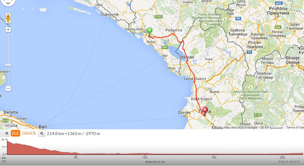 |
214k | 1363m | 50k descent (wheeeeeee!) into Albania. Oh. Taking the main road into Tirana, the capital. Again, no google street view so going off peoples experiences last year. |
 |
184k | 2954m | Out from Tirana, then head east into Elbasan. This apparently is not very nice. On up the Lumi Shkumbin valley, over 3 * 1000m hills, and into Macedonia. Quite a big day |
 |
185k | 1054m | another couple of 1000m peaks, but then its descend to sea level into Greece, and civilisation. |
 |
171k | 1436m | Stay by the coast, (my sun tan might need topping up) on road 2. |
 |
169k | 1518m | Stay on road 2. Its been a little flat so a nice 400m climb to wake the legs up 🙂 |
 |
162k | 1458m | Route 2 vanishes and I finally get to Turkey. Its a long way to go for an authentic kebab. The road starts to roll |
 |
199k | 2018m | Its not downhill to the finish. 😦 Not big, just constant rolling 200m hills. I cut off the D110 early as it gets very busy the further into Istanbul you go, and becomes the D100 which is banned by the organisers, (its awful). It means a few hills as I loop around to the north, but hopefully its quieter. Then into Istanbul via the Attaturk Aboreteum, (a forest with a statue in it) |
